“Bird Friendly” Brew: Honduran Shade-Grown Coffee

While Studying the Golden-winged Warbler in Honduras, CWF Biologist Learned about “Bird Friendly” Coffee

by Kelly Triece, Private Lands Biologist

Neotropical birds like this Gartered Trogan (Trogon violaceous) may benefit from the available fruits and insects on a shade-grown coffee farm © Laura Jackson

Did you enjoy a warm cup of coffee this morning? I know I did. Over 2.25 billion cups of coffee are consumed every day.


Coffee is also one of the world’s top agricultural exports in many developing countries. While I was in Honduras, with the Pennsylvania Golden-winged Warbler working group, I was given the opportunity to visit a shade grown coffee farm!


As I traveled across the country, I was able to enjoy many fresh cups of local Honduran coffee and learn about the importance of coffee as part of the Honduran history and local economy.


In 2011, Honduras became the number one coffee producer in Central America. Today, there are over 100,000 registered coffee producers in the country and over 90% of them are small producers. Coffee has become a vital part of the Honduran economy and family system, helping to generate small businesses and bring revenue to the local community.

The coffee fruit, or the cherry, is red upon ripening and is laid out to dry © K.Triece


In Honduras, coffee is harvested from November to March every year. Coffee is hand-picked and resembles a green or red cherry fruit when ripe. After ripening and picking, coffee must be dried and the outer coating, called the parchment, or pergamino must be removed. There are various methods of parchment removal and drying. Different drying and roasting techniques give way to differing quality, taste and aroma.


In its wild form, coffee is a small tree or shrub that grows in the understory of a forest. Traditionally, coffee production occurs on large farm fields, where the land is tilled and little native vegetation grows. Coffee producers often use this traditional method as a way to increase yield and fight off diseases susceptible to the plant. Recently, however, coffee producers have begun to grow shade-tolerant coffee which is grown under a forest canopy.


Shade-tolerant coffee production is a method which intends to incorporate the natural principles of ecology into agricultural production.  Shade tolerant or shade-grown coffee is grown under a natural forest canopy. Shade grown coffee can have multiple benefits — reducing pests, increasing pollination and creating important wildlife habitat. Shade grown coffee plantations often have increased leaf litter which reduces erosion and allows for improved water quality.

Coffee plant while it is flowering © K.Triece


Through the incorporation of native trees on farms, birds and natural predators will help reduce pest insects, which in turn, helps reduce the need for pesticides. Bird diversity is often higher on shade grown coffee farms since they eat the fruit, insects and nectar in the native tree canopy. These types of farming practices have also be termed “bird friendly” coffee, because they help support local bird populations, including migratory birds that stay in Honduras during their wintering months.

Lenca farms, a shade-grown coffee farm © K.Triece


Upon our visit to a shade-grown coffee farm, called Lenca farms in the little town of Marcala, we were greeted with a Golden-winged Warbler! Most of the farm grew coffee right under the native forest canopy. Many of the native trees, leaf litter and herbaceous plants were left intact. It was great to meet with local Honduran farmers, who are eager to create and maintain wildlife habitat on their farms. Many Hondurans recognize the value in wildlife and are willing participants in wildlife conservation.


Shade-grown coffee may be important as coffee continues to be a growing commodity crop worldwide. When farmers learn to grow food in conjunction with nature, not against it, the best yields and benefits for the environment can result.


We were very appreciate of our time a Lenca Farms, and we didn’t leave without a fresh cup right on site!


Check out Smithsonian Migratory Bird Center online to learn about the certification process for coffee farms called “Bird Friendly Coffee” and to learn how to buy bird friendly coffee!


Learn More:


Kelly Triece is the Private Lands Biologist for Conserve Wildlife Foundation of New Jersey.
Resurgence of New Jersey’s Fishers

After more than a century, fishers are returning to New Jersey

by Kendall Miller, Communications Intern

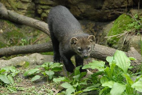
Fisher photo by Josh More via Flickr Creative Commons.


New Jersey’s forests lost a charismatic top predator when the fisher was extirpated nearly a century ago. Exploitation of the fisher for its pelt — coupled with excessive logging practices during the 19th and 20th centuries — caused decimated populations of this North American native across its entire range. However, through the implementation of conservation practices, this small, yet spunky forest carnivore is experiencing a comeback.


Despite its past disappearance from the state, the combined effects of trapping bans and nearby relocation projects (New York and Pennsylvania) are resulting in the fisher’s resurgence in New Jersey. Within the last decade, the return of fishers to New Jersey has been an exciting new possibility, with multiple reported sightings, photos caught via trail camera and anecdotal stories by the public.


Recently, two trappings by state officials in North Jersey, both within a mere month of one another, mark the return of fishers to the state of New Jersey, and speaks for the potential future of this species, as well as others.


What exactly is a fisher?

Source: Canadian Geographic

Found only in North America, fishers historically inhabited forested and semi-forested land from coast to coast, ranging from Virginia to Quebec in the east. Found in deciduous, coniferous and mixed forests, they prefer areas with dense canopy cover, and tend to avoid areas with human disturbances.


Also referred to as the fisher cat and Appalachian black cat, this animal looks like fluffy cat meets fox, with a wolverine-like disposition. However, it is neither a feline nor does it catch fish. The fisher (Martes pennanti) is a member of the Mustelidae family, which includes otters, badgers, martens, ferrets, minks, wolverines and more.


The fisher is a long bodied and short legged animal, with a bushy tail that makes up a third of its total body length. There is a substantial size sexual dimorphism between males and females. Males weigh 8-13 pounds and reach lengths between 35-47 inches. Females weigh between 3 and 7 pounds and are between 30-37 inches long. Males have grizzled fur due to blonde guard hairs on their neck and shoulders, while females are a uniform chocolate brown.


A generalist carnivore species, a fisher will eat anything it can catch — typically small- to medium-sized mammals and birds. Carrion and some nuts and fruits also make up a portion of its diet. They are known to eliminate weak or injured deer, especially in times of heavy snow pack.


While its diet may be general, one part is very special: this is the only predator of porcupines in the country. The prickly defenses of the porcupine protect it against almost all predators except the fisher, who has developed a special way of hunting its prey. It will chase a porcupine up a tree until it can go no further and falls. Then, it will make a head-first descent down the tree with the help of semi-retractable claws and feet that can turn nearly 180 degrees. The fall stuns the porcupine, allowing the fisher to access the unprotected underside.


These predators share prey with coyotes, bobcats, foxes and even raptors, creating competition with these species. Fishers have been known to travel hundreds of miles to meet their dietary needs, able to cross water if need be.


They live a solitary life-style, with home ranges between 1-3 square miles, seldom overlapping, which suggests territoriality. They are found to be active at any point during the day or night. Fishers make homes in dens year round, using a variety of forest resources such as tree hollows, stumps, debris piles, natural crevices and underground tunnels. Females with litters will use tree hollows that are far off the ground.


Fishers themselves have no natural enemies and few disease occurrences. Trapping by humans and vehicle collisions likely account for the majority of deaths throughout their range.


Learn More:


Kendall Miller is the Communications Intern for Conserve Wildlife Foundation of New Jersey.

Help Golden-winged Warblers Thrive in Sparta Mountain WMA

Comments on the Sparta Mountain WMA Forest Stewardship Plan are due Tuesday, March 1, 2016

by Emily Hofmann, Environmental Education Intern

Photo by New York-New Jersey Trail Conference

Wildlife in the Sparta Mountain Wildlife Management Area (WMA) need your help! Submit your comments on the new Forest Stewardship Plan by Tuesday, March 1, 2016.


Conserve Wildlife Foundation supports the new Forest Stewardship Plan for the Sparta Mountain WMA located in Sparta Township, New Jersey. The original Forest Stewardship Plan was introduced in 2009. The New Jersey Division of Fish and Wildlife, in partnership with New Jersey Audubon, recently updated and expanded upon the plan. The new revisions show a commitment to creating healthier forest habitat for wildlife, while abiding by the strict guidelines provided by third-party certification, along with agency regulations.


The new ten-year Plan, drafted by New Jersey Division of Fish and Wildlife and New Jersey Audubon Society, and conducted under an existing Forest Stewardship Plan for the wildlife area, will allow conservation actions to continue. The plan addresses the following key goals:

  • Improve the health, structure and diversity of the forests;
  • Create young forest habitat for birds and other wildlife that are of conservation concern;
  • Enhance foraging, nesting and roosting habitat for cavity dwelling birds and bats;
  • Suppress the spread of invasive species;
  • May provide basking habitat for turtles;
  • Protect and maintain views and vistas;
  • Improve passive recreational opportunities;
  • Protect water resources;
  • Monitor and evaluate stewardship activities


Kelly Triece, our Private Lands Biologist, has pointed out that 80% of New Jersey forests are currently between 60-99 years old, while only 5% of the forests are between 0-19 years old. CWF supports forest stewardship projects, like those presented in the new plan, that seek to even out this clear disparity and promote more diversity in age class of New Jersey forests. Increased diversity in forest age brings increased diversity in plant and animal species. This type of forest habitat has the potential to support over 125 bird species, including the Golden-winged Warbler.


Golden-winged Warbler. Photo by D. Kenny Golden.


The public comment period is an opportunity for you to support forest stewardship that will improve the health of the forest and create young forest habitat; essential for protecting the state endangered Golden-winged Warbler, as well as numerous other flora and fauna.


The Department of Environmental Protection needs to hear from you! To submit comments, visit DEP’s website. Provided below is a draft set of comments which you are welcome to use, as well as revise and submit. Remember, the deadline is Tuesday, March 1, 2016.


Learn More and Take Action:


Emily Hofmann is the Environmental Education Intern for Conserve Wildlife Foundation of New Jersey.


Suggested text:

To the New Jersey Department of Environmental Protection,

Please accept the following comments in support of adoption and implementation of the Sparta Mountain Wildlife Management Area Forest Stewardship plan. This new plan builds on an existing plan that has been under implementation for several years. The new plan seeks to addresses the long-term health of the forest and the critically important lack of young forest habitat by working to create new young forest habitat patches over the next ten years. In addition, the plan includes explicit goals to protect and enhance hydrologic resources, monitoring of priority wildlife populations, provide compatible wildlife recreational opportunities and adherence to strict third party certification principles and criteria. This plan is important because the resident and migratory birds, mammals, reptiles and amphibians that rely on young forest habitat are struggling to maintain themselves in places they were once commonly found. Throughout the Northeast, young forest habitat has diminished as forestland has been converted to development and abandoned farms and homesteads have matured to woodlands. As a consequence, a wide variety of wildlife have experienced the loss of the scrubby, patchy, disturbed portions of the forest that they rely on for food and cover.

The plan was developed based upon an understanding of the needs of wildlife in the Highlands Region and with a specific focus on ensuring that forest health is improved. The plan authors thoroughly reviewed the history of the region, considered the important water resources of Sparta Mountain, evaluated wildlife needs, recreational desires and community connections, and brought all of this together with a keen eye toward improving the health and vigor of the forest. The plan has gone through an extensive review by experts at the Department of Environmental Protection, has taken input from a wide-range of stakeholders and meets the requirements of a third party certification system. The plan is appropriate and needed given the mission of the NJ DEP and the NJ Division of Fish and Wildlife, the agency charged with management of the wildlife area and conserving wildlife. I encourage the Department of Environmental Protection to adopt and implement the Sparta Mountain Wildlife Management Area Forest Stewardship Plan.

Bahamas Revisited

Piping Plover Research and Conservation Five Years Later

by Todd Pover, Beach Nesting Bird Project Manager

CensusPine2


The wintering segment of the 2016 International Piping Plover Census has just wrapped up in the Bahamas. This marks six winters of my own involvement with piping plover conservation work in the Bahamas – starting with the last international census in 2011 – so I thought it would be a good time to reflect on the changes I have observed in the years between the censuses.


First and foremost, we now know much more about how many piping plovers winter in the Bahamas and where they are located, including some areas where there are particular high concentrations of piping plovers and other shorebirds. This knowledge is due to the significant increase in survey effort put forth by partners in the Bahamas during the census, but also surveys conducted by Bahamas National Trust and National Audubon Society, as well as our own work at Conserve Wildlife Foundation of New Jersey (CWF), in the years since 2011 to supplement the earlier surveys and better understand how piping plovers use the sites.

The author, CWF's Todd Pover, scoping out  piping plovers during the census.
The author, CWF’s Todd Pover, scoping out piping plovers during the census.


This is demonstrated by the results of the 2016 census. As just one example of how this extra research paid off, in 2011 when we visited Casuarina Point on Abaco for the census, we knew from local birders and e-Bird that piping plovers were frequently seen there, but not that it was only for a narrow window during low tide to forage, nor that depending on wind conditions or disturbance, they could be at another more remote flat across Cherokee Sound. So in 2016, we had surveyors in place at the correct tide AND in both locations at the same time, thus allowing us to record 26 piping plovers, instead of 0 in 2011. Using similar information gathered across the island we found 178 piping plovers in 2016, compared to 76 in 2011 (and 82 on Eleuthera in 2016 vs. 30 in 2011).

The CWF 2016 International Piping Plover Census team for Abaco and Eleuthera: Pam Prichard, Todd Pover, Stephanie Egger, Michelle Stantial, Emily Heiser, Brendan Toote (left to right).


Even with some oversights like those, the 1066 piping plovers tallied in the 2011 census revealed that the Bahamas was one of the most significant wintering locations for piping plovers, second only to Texas. And with band resight data, we now know that the Bahamas is THE most important winter location for the Atlantic coast population (as compared to the Great Lakes and Great Plains populations). Although the final count for the 2016 census is not complete yet, it has already topped the 2016 figure and will account for a good part of the remaining unknown wintering birds and locations. New surveys in the Turks and Caicos, more intensive surveys in Cuba, as well as the Southeast/Gulf Coast U.S. (which is critical for all three populations of piping plover) should make this the most comprehensive and informative survey to date.


While improved census results are important, one may reasonably still ask how the census is going to translate into better conservation. The Bahamas is a good example of what can be done with the data  last year the Bahamas government set aside the Joulter Cays as one of a series of new national parks, to a large degree based on its importance for shorebirds, especially piping plovers, as a result of information initially gathered from the census and follow-up surveys. This marked the first time shorebirds played a significant role in such a designation, so this is a watershed event for shorebird conservation in the Bahamas (and the Caribbean).


I have noticed other “sea changes” in attitude on a smaller scale. When I first visited the Bahamas (Abaco) during the 2011 census, aside for some birders, piping plovers were little known by the public there. Now when I come, I am recognized as the plover guy and piping plover bumper stickers can be spotted around the island on golf carts and trucks. There is even a new post card, entitled “Birds of the Bahamas” that has a piping plover side by side with a flamingo, the national bird. And there is refreshingly little of the rancor we sometimes have in the states over their protection – the habitats piping plovers use in the Bahamas, especially tidal flats, are also important for valuable resources, such as conch and bonefish, and other marine species, so protecting them is less of a conflict.

birds of the bahamas postcard


The important role the Bahamas plays in the piping plover life cycle is now much better known by the public and other stakeholders. Many of the participating partners have not only provided technical shorebird expertise during the surveys, but worked hard to provide education and outreach towards a long-term conservation goal. One area my colleague Stephanie Egger and I are most proud of in this realm is our Shorebird Sister School Network, where we pair up schools and students in the Bahamas and in New Jersey, using piping plover migration as the link. Now in its third year, this project is working to create a new generation of young conservationists (and piping plover lovers)!


This is not to say our work is done. There is still more to learn, a banding study is being conducted to help us better understand survival compared to other wintering (and breeding) regions, more detailed aspects of site fidelity, and how birds move around sites within islands. Still, piping plovers are no longer a novelty in the Bahamas as was largely the case when I first came in 2011. The challenge over the next five years will be how to harness the increased awareness and knowledge to aid recovery of this endangered species.


A special thanks to Friends of the Environment, who have been our piping plover partner on Abaco from the beginning, please check out all the great work they do! Also to the Disney Conservation Fund and The National Audubon Society for funding, as well as Bahamas National Trust for other support and the conservation work they do in the Bahamas in general. Thanks to the U.S. Geological Survey, sponsors of the International Piping Plover Census, for supporting CWF’s inclusion in the surveys. Thanks to Rolling Harbour Abaco for setting up the Abaco Piping Plover Watch this winter to help us keep track of piping plovers and raise local awareness. Thanks to those who participated in the CWF led 2016 census on Abaco and Eleuthera: Brendan Toote, of the College of the Bahamas, Michelle Stantial, of SUNY – ESF, Pam Prichard, and CWF’s own Stephanie Egger and Emily Heiser. And finally, thanks to our local citizen scientists on Abaco who participated in or provided valuable knowledge for the 2016 census, especially Ali Ball, our “super” volunteer!


Learn More:


Todd Pover is the Beach Nesting Bird Project Manager for Conserve Wildlife Foundation of New Jersey.

How You Can Help Fill-in Data Gaps

YOUR WILDLIFE SIGHTINGS CAN HELP INFORM NEW JERSEY’S BIOLOGISTS

By Michael Davenport, GIS Program Manager

Compared with most of the states within the United States, New Jersey is relatively small in area. However, it is still too large for biologists within New Jersey’s Endangered and Nongame Species Program (ENSP) to survey every inch of the state for rare species at all times. Therefore, ENSP has created a Rare Wildlife Sighting Report Form with which any bird watcher, hiker, fisherman, and anyone else with knowledge on how to identify New Jersey’s rare wildlife, may submit information on rare species which they may have come across in their travels. This information assists ENSP biologists in monitoring their species’ numbers and whereabouts and may aid in targeting areas for future surveys. Conserve Wildlife Foundation of New Jersey (CWF) staff work very closely with ENSP to encourage the public to submit their observational data and then process the information which gets submitted.

A spotted salamander, photographed during a quiet moment along the road shoulder. © Brett Klaproth

The first step in reporting rare species sightings is to first determine whether the species you observed is a species which is tracked. Tracked species are those listed in New Jersey as endangered, threatened, or special concern. The lists of these species can be found on these ENSP’s websites:  endangered & threatened species and special concern species.

The greatest need for data is for those species which are new to the proposed list of endangered, threatened, or special concern species. Because they did NOT previously have an imperiled status, they have largely been ignored in terms of survey effort and/or data acquisition. At the current time, there is a great need for data regarding observations of the following species:

Reptiles

Amphibians

Butterflies

Once you have determined that you observed a rare species, the next step is to complete a Rare Wildlife Sighting Report Form. You may complete one of these forms if you made the observation yourself – second-hand observations or information whose source was a report, letter, conversation, or other document will not be accepted. Also, one form must be completed per species. Thus, if you observe a heron rookery comprised of great blue herons, tricolor herons, and snowy egrets, then three sighting report forms may be submitted.

Rare Wildlife Sighting Report Forms are available for download and/or printing here. Part of the process of completing the form is to submit a map of the location where the animal was observed. This is critically important for reasons to be discussed later. The preferred map to submit is an aerial image of the area which you have marked with the animal’s location; however, a topographic map is also acceptable. Aerial images may be accessed via Google maps. Topographic maps can be accessed here. In addition to the form and map, it is also extremely helpful if you can submit at least one photograph of the animal in order for an ENSP biologist to verify the identification of the species.

In 2016, the NJ Endangered & Nongame Advisory Committee approved that the rough green snake be added to the state's list of Special Concern species. © Keara R. Giannotti
In 2016, the NJ Endangered & Nongame Advisory Committee approved that the rough green snake be added to the state’s list of Special Concern species. © Keara R. Giannotti

After you mail in your form and map to ENSP, CWF or ENSP staff will enter it into their tracking database at which point it will receive an Observation ID number. You will then receive an e-mail acknowledging receipt of your form and providing you with your Observation ID number in the event you wish to follow-up with additional information or inquire as to whether the biologist has reviewed your form.

The form then goes to a CWF or ENSP biologist who will evaluate it to determine whether it is a valid sighting and whether it should be integrated into the next version of ENSP’s Landscape Project. This is why receiving accurate locational information along with the sighting report form is crucial. The Landscape Project is a Geographic Information Systems (GIS) product whereby critical areas are identified for imperiled species based upon species locations as well as land-use classifications. The resulting maps enable state, county, municipal, and private agencies to identify important habitats and protect them in a variety of ways. This information is even utilized to regulate land-use in the state and attempt to preserve whatever endangered and threatened species habitat remains in New Jersey.

A common misperception many New Jersey nature watchers have is, if they happen to report their rare species sightings to institutions such as Audubon or Cornell (e-bird), that information will make its way to the state’s Endangered and Nongame Species Program. That is not the case. ENSP needs you to submit your data directly to them. So, please, become a Citizen Scientist and assist both CWF and ENSP in tracking New Jersey’s rare species, in the hopes that our work can prevent them from becoming rarer.

If you have collected a large amount of data and submitting it via multiple Sighting Report Forms may be too time consuming, please contact Mike Davenport, CWF’s GIS Program Manager, at Michael.davenport@dep.nj.gov Other options exist for data submittal (Excel spreadsheets for example) so long as all of the required information is included.

New Jersey’s Species Status Review Process

HOW A SPECIES BECOMES LISTED AS “ENDANGERED” IN NEW JERSEY

By Michael Davenport, GIS Program Manager

How does the state’s Endangered and Nongame Species Program (ENSP) determine whether a species is imperiled or secure within the state? The process for determining a species’ state status is known as the “Delphi” method of species status review and it is a process which Conserve Wildlife Foundation of NJ (CWF) staff assists the state with.

Monarch adult edit
In 2015, the NJ Endangered & Nongame Advisory Committee approved that the monarch butterfly be added to the state’s list of Special Concern species. Photo courtesy of Thomas Gorman.

The ENSP endeavors to complete a review of all species currently included on the Endangered and Nongame lists every 5-10 years. In addition, other species groups not currently included on those lists may be reviewed for status as well. At any given time, there may be several status reviews being conducted.

The first step taken in conducting a status review is to identify experts and invite them to participate as a member of a review panel. Members of the panel may be comprised of experts within academia, government agencies, non-profits, or private consultants as well as others.

Once a sufficient number of experts have agreed to participate, staff within the ENSP and CWF will compile background material for the species being reviewed. This may include reports, survey data, and data contained within the state’s Biotics database which is the electronic warehouse for all imperiled species data in New Jersey. This background data, as well as a list of the species being reviewed, and definitions of the status options, are then sent to the panelists for Round 1 of the review.

Delphi reviews are comprised of multiple “Rounds”. For each round, each panelist will choose a status for each species based upon that panelist’s expertise as well as the background material. The panelist then sends their selections and justification regarding each species to ENSP or CWF staff who compile the results submitted by all panelists. The review is completed anonymously, so the panelists do not know the identities of the other participants.

In 2016, the NJ Endangered & Nongame Advisory Committee approved that the eastern hognose snake be added to the state's list of Special Concern species. © Thomas Gorman
In 2016, the NJ Endangered & Nongame Advisory Committee approved that the eastern hognose snake be added to the state’s list of Special Concern species. © Thomas Gorman

For each species, the panel must reach consensus of at least 85% of the respondents for a species’ status to be determined. If consensus is not reached during the first round, then that species will move on to be reviewed in Round 2. For each new round, the panelists’ status choices during the prior round, as well as all the comments made, are available to the panel, so that reviewers can consider the weight of evidence and other reviewers’ opinions on status as they prepare to vote again. This continues until consensus is reached for all species under review.

Once consensus is reached for all species or, if after four rounds have passed and consensus could not be reached for some species, ENSP or CWF staff will take the compiled Delphi results to the Endangered and Nongame Species Advisory Committee (ENSAC). ENSAC reviews the results and makes the final recommendations on status for those species for which consensus was not reached by the expert panel. Based upon ENSAC’s recommendations, any changes to the Endangered and Nongame lists must go through a formal rule-making process before those changes can be made official.

The Delphi review process is a science-based, anonymous review by those with the most expertise on the species within New Jersey. A great deal of thought and time go into preparing for and carrying out a review and CWF has played a major role in assisting with the process. From the blue whale to fairy shrimp, each species will ultimately receive a state status, leading the way for conservation action.


The following are state conservation status categories; the last, “Not Applicable”, is used only during the status review and is not a legal status category.

  • Endangered
    Applies to species whose prospects for survival within the state are in immediate danger due to one or several factors, such as loss or degradation of habitat, overexploitation, predation, competition, disease or environmental pollution, etc. An Endangered species likely requires immediate action to avoid extinction within New Jersey.
  • Threatened
    Applies to species that may become Endangered if conditions surrounding it begin to or continue to deteriorate. Thus, a Threatened species is one that is already vulnerable as a result of small population size, restricted range, narrow habitat affinities, significant population decline, etc.
  • Special Concern
    Applies to species that warrant special attention because of inherent vulnerability to environmental deterioration or habitat modification that would result in their becoming Threatened. This category would also be applied to species that meet the forgoing criteria and for which there is little understanding of their current population status in the state.
  • Secure/Stable
    Applies to species that appear to be secure in New Jersey and not in danger of falling into any of the preceding three categories in the near future.
  • Undetermined/Unknown
    Applies to a species that cannot be assigned a status of endangered, threatened, special concern or secure/stable because not enough information exists on which to base a judgment.
  • Not Applicable
    Applies to species that do not occur in New Jersey, including occasional non-breeding strays and transient breeders that fail to persist.

CWF’s Online Field Guide Expands

23 WILDLIFE SPECIES ADDED TO CWF’S ONLINE FIELD GUIDE

By Michael Davenport, GIS Program Manager

Conserve Wildlife Foundation of NJ’s online field guide, a one-of-a-kind free reference focused on New Jersey’s wildlife, has recently expanded to include 23 additional species. As a result of recent status reviews by the state’s Endangered and Nongame Species Program for reptiles, amphibians, and butterflies, additional species within the state will be receiving an imperiled status of either Endangered, Threatened, or Special Concern. Six reptile species are being added as well as four amphibians and thirteen butterfly species.

Baltimore_Checkerspot_1
The Baltimore checkerspot, a species recently added to CWF’s on-line field guide. Photo courtesy of Eric C. Reuter.

Later this week, two additional blog entries will be posted regarding the status review process and the new listings. The posts will be: “Species Status Review process” (WEDNESDAY); and “How you can help fill-in data gaps” (FRIDAY).

The list of “new” species is below and each species name links to its field guide entry on our website:

REPTILES

AMPHIBIANS

BUTTERFLIES

Science in the Mangroves

Update from Brazil: “We are Going to Have to Science the ‘Heck’ Out of This”

by Dr. Larry Niles, LJ Niles Associates LLC

larger view of brazil


We came to Brazil to conduct a rigorous scientific study of the wintering population of shorebirds in a place where the land and sea act against any rigorous protocol. It would be easier to just go out and count birds and identify their habitats and prey, but our charge is more difficult.


The survey wraps around satellite imagery, strange unintelligible wavelength data coming from satellites hovering over the earth that can be transformed into brilliant and useful maps in the right hands. Those hands belong to Professor Rick Lathrop and his post doc Dan Merchant. Rick leads the Center for Remote Sensing at Rutgers and he and I have collaborated on projects ranging from municipal habitat conservation planning to Arctic red knot habitat mapping. He has created one of the most alarming maps that every person from New Jersey should know about.

nj_landchange450

The mapping of Reentrancias Maranhenses, an internationally recognized site of ecological importance is especially tricky. Our research platform is a 50-foot boat and we will be out of cell and internet contact for much of the time. Our method of collecting data for the mapping was devised by the whole team, but especially with the help Professor David Santos of the University of Maranhao, my colleague Dr. Joe Smith and Humphrey Sitters of the International Wader Study Group.

Our 50-foot catamaran

It focuses on collecting bird and habitat information using randomly selected survey points. In other words, we will try to pick places at random to survey so that when we combine them we will have a sample that represents the entire area, not just the places we surveyed. It’s like trying to figure how many different kinds of chocolates are in a valentine. If you take them all from one side then you might have sampled the chocolate covered cherry section leading to believe they are all one kind. But if you choose chocolates at random than you will find the box includes other kinds,  caramel or fruit or nutty chocolates. This is making me hungry, but you get the point.


The area  of our box we is very large, bigger than New Jersey, and it grows and shrinks every day with the tides. So, sampling is tricky business because a sample at low tide, when the tide is out exposing vast areas of intertidal mud and sand flat, is very different than when the tide is high. So we will be classifying habitat, or stratifying it, so we  can focus on limited survey time to get the best sample.


Once collected we can start making maps.  All data will be geo referenced – or located precisely  with GPS units – so it can be accurately mapped. With this, we will train the satellite maps to outline the habitat best for shorebirds.


All this while exploring areas that have received little scientific scrutiny and under tropical conditions, almost daily rain, a persistent 20 mph wind and summer heat.  Add parasites, mosquitoes and diseases like malaria and one can see this a rugged undertaking.


Our crew is up to it.  Besides those mentioned above Mark Peck from Royal Ontario Museum, Danielle Paluto from the Brazilian CEMAVE (a counterpart to our USFWS), Steve Gates a veteran of expedition on other SA trips, shorebird expert Dr. Mandy Dey, Stephanie Feigin from Conserve Wildlife Foundation of New Jersey and the author round out a dream team of bird study in difficult places.

Our crew banding shorebirds in Brazil in 2014.


Learn more:


Dr. Larry Niles has led efforts to protect red knots and horseshoe crabs for over 30 years.


CWF Biologists Travel to Brazil to Study Red Knots

On our Expedition to Study Shorebirds along the Northern Coast of Brazil

By: Dr. Larry Niles, LJ Niles Associates LLC

Ana Paula with Red Knot

The largest mangrove forest in the world covers the Brazilian coastline at the equator near the mouth of the Amazon river. The forest extends out into the Atlantic in long peninsulas tipped by wind swept and mostly inaccessible beaches. The forest, beaches and their long intertidal mud and sandy low tide flats support the largest wintering population of shorebirds in the hemisphere, perhaps the world. The red knot, a listed species in both North and South America, also uses this remote tropical coast.

Boat Trip Route
Boat Trip Route
Catamaran
Catamaran


With scientists from the U.S., Canada, England and Brazil, we will attempt a large scale mapping of this important habitat using state-of-the-art satellite mapping. We will do this from a 50-foot catamaran and two zodiacs hopping from one mangrove estuary to another and conducting bird surveys targeting key areas over a 150 mile-section of the coast. We will be the first to survey some areas. Our goal is to figure out the main threats to both bird and habitat.


To understand the importance of this area one has to think about it like a shorebird. Although born in the Arctic they actually spend only a few months there. They spend a few months moving from their nesting area to their wintering area. They spend the rest of their lives, the majority of their year in the wintering area. A threat to the wintering area would be grave.


Most of our survey zone is part of the Reentrancias Maranhenses, a protected area of the state of Maranhao, Brazil. Our catamaran captained by William Thomas will leave from a small town near the city of Sao Luis, Brazil. From there we will sail along the coastline moving in and out of the mangrove islands to survey shorebirds, habitat and marine invertebrates. We will “geo reference” all data, or take detailed coordinates so the data can be reproduced on satellite mapping.

Satellite Map
Satellite Map


Satellite maps aren’t really maps as most people understand — pictures or drawings of a section of the earth — they are digital files of remotely sensed data, they are only wavelengths of light that must be interpreted to represent actual habitat. We will train the satellite data so that each habitat will be represented by a combination of spectral data — colors in sense.

Environmental disturbance. Photo by Mark Peck.

Once completed, we can relate the habitat maps with information on birds, their prey and equally important, the threats to the birds and prey. For example, shrimp farming is growing in this area. Entrepreneurs are stripping the intertidal zone of mangrove forest, diking the area and then growing shrimp. Once the area accumulates too much waste and chemicals, they abandon the site and move on to damage another mangrove forest. We will determine which areas are of importance to the birds and potential targets for shrimp farmers. But there is more: oil spills, disturbance from tourists, water pollution are among many.


Over the next three weeks, we will be reporting on our work on this blog.

Log of Red Knot DbY7 with geolocator.


Learn more:


Dr. Larry Niles has led efforts to protect red knots and horseshoe crabs for over 30 years.

Providing Young Forest Habitat for the Golden-winged Warbler

CWF and partners have created or restored over 225 acres of Golden-winged warbler habitat in New Jersey since 2012

 by Kelly Triece, Private Lands Biologist

Golden Winged Warbler. Photo by D. Kenny.

Take a look at this Golden-winged warbler — a Neotropical Migrant songbird that breeds in New Jersey. This songbird is a species of special conservation concern in the United States and endangered in New Jersey, experiencing population declines due to loss of young forest habitat.

 
Did you know? In the past 30 years, over 11,000 acres of upland shrub and emergent wetland habitat have been lost to succession in New Jersey. This habitat is important for Golden-winged warblers because it is their primary breeding habitat. Fortunately, their secondary habitat, upland forests, have remained stable in the state.


Therefore, it has been the goal of many wildlife management agencies to continue to create young forest habitat, while protecting upland forests as well.

 
Conserve Wildlife Foundation and our partners (Natural Resources Conservation Service, New Jersey Division of Fish and Wildlife and New Jersey Audubon Society), have worked with private landowners to create or restore over 225 acres of Golden-winged warbler habitat since 2012 in New Jersey.


Our managed forests have a statistically significant higher diversity of birds than unmanaged sites!

Young forest habitat managed for Golden-winged Warbler. Photo by Kelly Triece.
Young forest habitat managed for Golden-winged warbler. Photo by Kelly Triece.

Young forest habitat, also known as scrub-shrub habitat, is new or regenerating forest that is less than 20 years old. Young forest habitat is important for many birds, especially the Golden-winged warbler. The open canopy of a young forest also helps provide food such as berries and insects to newly fledged birds, wild turkey, ruffed grouse, reptiles, black bears, bobcats, and butterflies.


Golden-winged warbler home range

The breeding range of the Golden-winged warbler extends along the Appalachians from the northern portion of Georgia in the south to Vermont in the north. The winter range for this species is southern Mexico and Central and South America.


Follow us in February 2016 when biologist Kelly Triece travels to Honduras to see the Golden-winged Warbler in its winter habitat!


Learn more and get involved:


Kelly Triece is the Private Lands Biologist for Conserve Wildlife Foundation of New Jersey.